

HuntStand is the ultimate app for hunters and land managers. Recognized by Outdoor Life Magazine as the Best Hunting App available, it is North America's number one choice for hunting and land management. With over 6 million downloads, this app offers a range of powerful features that make planning and executing your hunting trips easier than ever before. With rich 3D mapping, you can navigate your hunting terrains with precision, while the advanced weather and game movement forecasts help you determine the best times to hunt. The app also provides extensive property line insights, including private and public property boundaries, curated public land and hunting land maps, and even a nationwide rut map. With a free account, you can enjoy high-resolution aerial imagery, manage your trail cameras effortlessly, access comprehensive weather forecasts, and much more. For even more benefits, you can upgrade to HuntStand Pro or HuntStand Pro Whitetail, which offer additional features like nationwide property boundaries, recent satellite imagery, real 3D maps, and a whitetail activity forecast. Download HuntStand for free today and revolutionize your hunting experience.
Features of HuntStand: GPS & Hunting Maps:
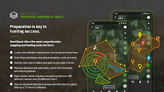
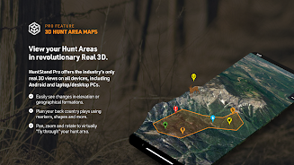
> Rich 3D Mapping: Plan your hunting areas with precision using dynamic 3D maps.
> Group Hunt Areas: Easily share hunt areas with hunting buddies, lease partners, and family members for seamless collaboration.
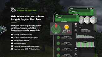
> Advanced Weather & Game Movement Forecasts: Stay informed with exclusive 7-day whitetail activity forecasts specific to your hunt area.
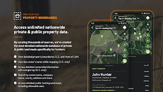
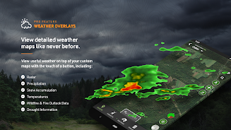
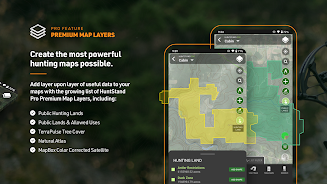
> Extensive Property Line Insights: Dive deep into private and public property details with nationwide boundaries and curated maps.
> Nationwide Rut Map: Access the only nationwide county-level rut map available to optimize your hunting strategies.
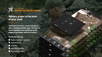
> High-Resolution Aerial Imagery: Create detailed maps of your hunting areas using high-resolution aerial imagery.
Conclusion:
With rich 3D mapping and advanced weather forecasts, you can plan your hunts with precision. Collaborate seamlessly with others through group hunt areas and explore extensive property line insights. The nationwide rut map and high-resolution aerial imagery provide valuable information to optimize your strategies. Download HuntStand today and unlock even more features for an unparalleled hunting experience.
screenshots


Comment
-
I love this app. It would be nice to be able to overlay other animals besides big game. Being able to mark clusters of birds (ie, upland game birds, turkey, waterfowl) would be awesome as well, WITHOUT having to pay another subscription. Also, being able to send out a general alert to huntstand users in my area about dangers (ie. washed out roads, closed roads etc) while out would be essential, instead of screenshotting and sending it to my hunting friends.May 25, 2024 22:31:44
-
Great app. I'm still learning how to use it but so far it's been easy to use and functional. Definitely would recommendMay 25, 2024 10:08:04
-
Valuable resource for my small hunting parcel. Easy to use and a great tool to have while out on your land. Keep track where all your stands, cameras and future stand placements are at all times. I love the face that you can see where the property lines are at and who owns them for great. All in all excellent app. All it really needs is hunting conditions and predictions to be a all inclusive app.May 24, 2024 17:30:38
-
Incredibly useful for hunting or even just exploring the outdoors. I used it all last year scouting and hunting for mule deer as well as hiking with my daughter. The property lines and public land filters saved me many hours trying to find legal areas to hunt in an area surrounded by ranches and other private property. The only thing I'm not crazy about is the crosshair UI for drawing lines and boundary shapes. Free drawing with a stylus would be a nice improvement.May 24, 2024 14:42:39
-
Great app. Just wish it had an updated map. My ground on this map looks nothing like it does now or has for the past 3-4 years. Other than that i love this app and use it frequently. (UPDATE) just spent 25 bucks on the pro version thinking it would show me more recent pics of my ground. Instead it has old pictures of the ground before they were even put back in trees. Cant believe I just wasted my money on older pictures.May 24, 2024 13:52:41
-
Edit for August of 2020, I've been using the app since 2016 and I was gonna switch to Onx but since their satellite image's aren't updated and alot of people are getting disappointed in the way the app is ran and having issues so I've decided to keep HuntStand and upgrade to the pro membership this year. Don't let us down HuntStand I've tried most of the other competitors from Onx to BaseMaps and just couldn't seem to like them.May 24, 2024 11:01:18