
UgCS for DJI

| Package ID: | |
|---|---|
| Latest Version: | vv2.39.2524 |
| Latest update: | Apr 20, 2024 14:40:12 |
| Developer: | SPH Engineering |
| Requirements: | Android |
| Category: | Tools |
| Size: | 80.67 MB |
Rating :4.3
The UgCS for DJI app is a game-changer for drone enthusiasts and professionals alike. With this app, you can connect your DJI drone to your computer and easily upload and execute pre-planned survey missions. Whether you're conducting an AreaScan, Photogrammetry, or Vertical scan, this app has got you covered. But that's not all - the app also functions as a stand-alone application, allowing you to manually pilot your drone and capture stunning photos and videos. With compatibility for a wide range of DJI drones, live camera view, and telemetry data monitoring, the UgCS for DJI app is an essential tool for any drone pilot. Get it now and take your drone missions to new heights!
Features of UgCS for DJI:
> Establishes a connection between DJI drone and UgCS desktop for automatic mission planning and execution.
> Compatible with various DJI drone models, including Mavic Pro, Phantom series, and Inspire series.
> Allows users to manually fly DJI drones and capture photos or videos.
> Provides access to features such as flight simulator, live HD camera view, and camera settings control.
> Enables users to upload and execute pre-planned missions from UgCS desktop to DJI drones.
> Supports metric and imperial units, and provides telemetry data for monitoring.
Conclusion:
The UgCS for DJI App is a comprehensive tool for drone survey missions. It allows users to easily connect their DJI drones to the UgCS desktop, facilitating automatic mission planning and execution. With compatibility with various DJI models, users can also manually fly their drones and capture media. The App offers a range of features, including a flight simulator, live camera view, and camera control, enhancing the user experience. With its ability to upload pre-planned missions and provide telemetry data, the UgCS for DJI App is a must-have for drone enthusiasts and professionals alike. Click the link to download and unlock the full potential of your DJI drone.
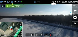
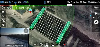
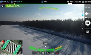
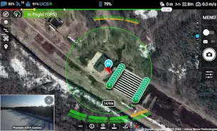
screenshots


Comment
-
It's okayApr 25, 2024 21:38:56
-
Will the next update support the NASA v2 system. It will be very useful for self assembled UAV. Thank you!Apr 25, 2024 14:01:45
-
GreatApr 25, 2024 09:44:51
-
Purchased this software to use on a special job in the mountains because it had terrain following. Drone crashed into the side of the mountain. I was on the test flight verifying the elevations so I had the elevation set higher than I thought I would need it...around 250 ft AGL. While monitoring the flight I noticed it was getting too close to the terrain and hit return home on my controller. I got no response and as I was hitting return to home on my laptop the drone crashed. I understand that the DEM is not supposed to be highly accurate, but you would think 250 feet would have been sufficient to minimize risk. I gave 2 stars because I still like the idea of the software but the crash set things back by several months and thousands of dollars. It would be great to utilize the DEM with survey points to verify/rectify the UgCS DEM and allow the drone to fly more accurately. I tried contacting UgCS about these issues and never heard back.Apr 25, 2024 05:32:08
-
Unable to update to latest version, Recieved error code 505, uninstalled, now will not even reinstall. Was a great app before, update needs fixedApr 24, 2024 01:23:27
-
I could not update to most recent version...tried uninstalling and now cannot re-install. Also unable to use without a data connection...makes remote work virtually impossoble. I gave 3 stars though cause when it works it is fantastic...Apr 23, 2024 15:23:52