Chizroid

| Package ID: | |
|---|---|
| Latest Version: | v18.9 |
| Latest update: | Jun 18, 2024 11:27:45 |
| Developer: | |
| Requirements: | Android |
| Category: | Travel & Local |
| Size: | 5.26 MB |
| Tags: | Travel Navigation |
Discover the breathtaking beauty of Japan like never before with the Chizroid app, a topographical map viewer exclusively designed for Android. Immerse yourself in the rich cultural heritage of Japan as you explore its diverse landscapes, from majestic mountains to tranquil lakes and bustling cities. With Chizroid, you can navigate through the country's topographic maps, featuring tiles provided by the renowned Geospatial Information Authority of Japan. But that's not all! You can also switch to OpenStreetMap to explore other countries, search for GPS locations, bookmark your favorite points of interest, measure distances, create routes, and even import GPX files. It's the ultimate companion for your outdoor adventures!
Features of Chizroid:
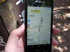
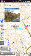
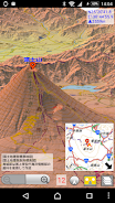
⭐️ Topographical map feature: The app provides a topographical map that allows users to view detailed terrain information of Japan. This feature is exclusive to Japan and uses official map tiles from the Geospatial Information Authority of Japan, ensuring accuracy and reliability.
⭐️ OpenStreetMap support: Users can also view maps from OpenStreetMap, providing a global view and access to maps of countries outside of Japan. This feature allows users to explore different regions and navigate unfamiliar territories.
⭐️ Web map tile feature: This feature enables users to access web map tiles, providing additional map options and customization possibilities. Users can choose from a variety of map styles and sources to suit their preferences and needs.
⭐️ GPS location search: The app includes a GPS location search feature, allowing users to easily find their current location on the map. This functionality is useful for navigation purposes and exploring nearby points of interest.
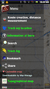
⭐️ Bookmark feature: Users can save points of interest (POI) by bookmarking them. This feature enables quick access to previously saved locations, making it convenient for users to plan and revisit specific places.
⭐️ Distance measurement and route creation: The app offers distance measurement and route creation tools. Users can measure distances between points on the map and create routes, whether it's a straight line or a more complex path. This functionality is beneficial for outdoor activities, hiking, and planning routes for travel.
Conclusion:
The Chizroid app is a powerful topographical map viewer that provides users with a range of features for exploring and navigating maps. With access to topographical maps of Japan, support for OpenStreetMap, web map tiles, GPS location search, bookmarking, and distance measurement and route creation tools, this app offers a comprehensive and user-friendly experience. Download the app now to enhance your mapping and navigation capabilities.
screenshots
Comment
-
Nice browser for GSI map. I love this!Jun 23, 2024 20:39:27
-
A very useful program to view GPX files. Setting the default map to Google showed better street and road details, but suffers from Google's policy of not showing commercial establishment's names when they have not paid. The display shows four useful parameters on one screen. These are 1- Location on map 2- Distance from origin 3- Time and date * 4- Elevation (altitude) * Unfortunately time and date are displayed relative to current position and not the coordinates of the map. ** Better than MyTracksJun 22, 2024 17:02:35
-
NicvJun 22, 2024 05:16:30
-
au C01にて使用していますが、軽快で安定した動作に満足しています!Jun 21, 2024 08:09:28
-
18MB UpdateJun 19, 2024 19:06:07
-
works perfect. great app! thanks for feedback. 1st app i installed on this deviceJun 19, 2024 08:14:45
